Mount LeConte via Alum Cave Trail
Carte interactive
Profil de la trace GPS
À propos de cette trace GPS
Nom : Trace GPS Mount LeConte via Alum Cave Trail, itinéraire, parcours
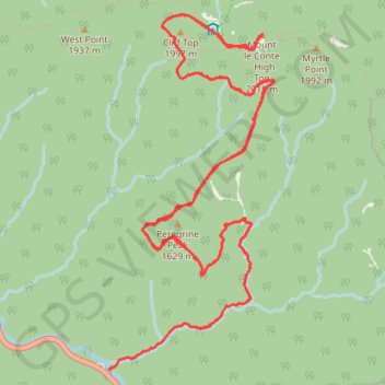
Départ : Alum Cave Trail, Sevier County, East Tennessee, Tennessee, United States (35.62911 -83.45090)
Arrivée : Alum Cave Trail, Sevier County, East Tennessee, Tennessee, United States (35.62913 -83.45086)
Coordonnées : 35.62911 -83.45090 35.65579 -83.43558
Autres traces GPS
Cliquez sur une trace GPS pour visualiser son itinéraire, ses statistiques et son profil.
Great Smoky Mountains Appalachian Trail
United States > North Carolina > Clay County
Hike through Great Smoky Mountains along Appalachian Trail via Standing Indian, Ridgepole Mountain, Yellow Bald, Wine Spring Bald, Copper Ridge Bald, Cheoah Bald, Wauchecha Bald, Fontana Dam, Thunderhead Mountain, Clingmans Dome, Mount Kephart and Mount Guyot. #Hike #Mountain #Nature #Forest #Lake #Appalachian
Distance : 231,7 Km • Dénivelé positif : 8 873 m • Altitude maximum : 2 013 m
Mount Le Conte - High Top
United States > Tennessee > Sevier County
Hike from Alum Cave Bluffs Trailhead to Mount Le Conte via Walker Camp Prong, Alum Cave Trail, Peregrine Peak, Cliff Top, Bull Head Trail and Boulevard Trail in the Great Smoky Mountains National Park. #Hike #Mountain #Nature #Forest
Distance : 18,0 Km • Dénivelé positif : 1 406 m • Altitude maximum : 1 994 m