Ben Nevis by the Mountain Path
GPX file from Walkhighlands; file is copyright Walkhighlands and must not be publicly shared on other websites. Do not remove this notice.
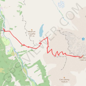
- Distance : 16,1 Km
- Dénivelé positif : 1 357 m
- Altitude maximum : 1 337 m
- Dénivelé négatif : 1 357 m
- Altitude minimum : 16 m
Carte interactive
Profil de la trace GPS
À propos de cette trace GPS
Nom : Trace GPS Ben Nevis by the Mountain Path, itinéraire, parcours
Départ : Glen Nevis Road, Achintee, Glen Nevis, Highland, Écosse, PH33 6TE, Royaume-Uni (56.81082 -5.07713)
Arrivée : Glen Nevis Road, Achintee, Glen Nevis, Highland, Écosse, PH33 6TE, Royaume-Uni (56.81080 -5.07712)
Coordonnées : 56.79591 -5.07713 56.81082 -5.00368
Autres traces GPS
Cliquez sur une trace GPS pour visualiser son itinéraire, ses statistiques et son profil.
Ben Nevis by the Mountain Path
Royaume-Uni > Écosse > Highland > Glen Nevis > Achintee
GPX file from Walkhighlands; file is copyright Walkhighlands and must not be publicly shared on other websites. Do not remove this notice.
Distance : 16,1 Km • Dénivelé positif : 1 357 m • Altitude maximum : 1 337 m