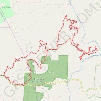
Big South Fork MTB Loop
Mountain Bike loop in the Big South Fork National River and Recreation Area. Cumberland River South Fork. Scott State Forest. #MTB #Loop #River #Forest #Nature
- Distance : 52,2 Km
- Dénivelé positif : 1 226 m
- Altitude maximum : 492 m
- Dénivelé négatif : 1 226 m
- Altitude minimum : 356 m
- Temps en mouvement : 5 h 50 m
- Vitesse en mouvement : 8,9 Km/h
- Vitesse maximum : 53,1 Km/h
- Temps total : 7 h 16 m
- Vitesse globale : 7,2 Km/h
- Date : 27.07.2020
Carte interactive
Profil de la trace GPS
À propos de cette trace GPS
Nom : Trace GPS Big South Fork MTB Loop, itinéraire, parcours
Départ : Bandy Creek Loop, Scott County, East Tennessee, Tennessee, United States (36.48808 -84.69839)
Arrivée : Bandy Creek Loop, Scott County, East Tennessee, Tennessee, United States (36.48807 -84.69844)
Coordonnées : 36.47303 -84.73916 36.53598 -84.63554
Autres traces GPS
Cliquez sur une trace GPS pour visualiser son itinéraire, ses statistiques et son profil.
Big South Fork National River and Recreation Area
United States > Tennessee > Scott County
Scott County Dia
Distance : 29,2 Km • Dénivelé positif : 668 m • Altitude maximum : 487 m